anything
AirNav RadarBox
Welcome, Guest. Please login or register.
Did you miss your activation email?

Login with username, password and session length


Author Topic: Using an Open Street Map (OSM) layer in Radarbox  (Read 11426 times)

0 Members and 1 Guest are viewing this topic.

hungerford1

  • New Member
  • *
  • Posts: 20
Re: Using an Open Street Map (OSM) layer in Radarbox
« Reply #15 on: October 10, 2011, 01:48:15 PM »
Cheers, need some spectacles i think

Pinza

  • Full Member
  • ***
  • Posts: 248
Re: Using an Open Street Map (OSM) layer in Radarbox
« Reply #16 on: October 22, 2011, 07:16:27 PM »
Hi Tarbat,

Have been a user of AirNav3D v4.03 since it first came out. Impressive as this is, I now want a more realistic/accurate 2D representation of planes.

Went for 3D initially as, living in the Midlands, my default 2D map was a sea of blackness and hard to picture where planes really where.

Followed instructions in this thread (and more detailed ones in the zip attachment in first post) - worked a treat first time - many thanks!

Only problem I have now is creating a suitable colour scheme.

OSM map area I have created covers the paltry 20 mile radius I see from indoor aerial - this map is predominately white so need to create a colour scheme that works on that, but also one that shows planes outside my new OSM map on the default black background!

I suppose I could make default (non OSM area) white based. Will try that now.

Would be nice is OSM maps could be integrated!

Sincere thanks for your work and sharing it via this thread.
Chris

« Last Edit: October 22, 2011, 07:18:42 PM by Pinza »

tarbat

  • ShipTrax Beta Testers
  • Hero Member
  • *
  • Posts: 4219
    • Radarbox at Easter Ross
Re: Using an Open Street Map (OSM) layer in Radarbox
« Reply #17 on: October 23, 2011, 08:27:12 AM »
Would be nice is OSM maps could be integrated!

Airnav have managed to integrate OSM into ShipTrax, so hopefully they can do the same for Radarbox in the next release.

vonsmalhausen

  • Hero Member
  • *****
  • Posts: 733
Re: Using an Open Street Map (OSM) layer in Radarbox
« Reply #18 on: October 23, 2011, 12:56:04 PM »
That would be great, i'm realy hoping for this

STR-Spotter

  • New Member
  • *
  • Posts: 2
Re: Using an Open Street Map (OSM) layer in Radarbox
« Reply #19 on: June 27, 2012, 02:04:20 PM »
Hey there,

sorry for pulling up this thread, but i think it´s the best way to post it here.

I´ve tried to get an OSM layer for my region, but it doesn´t work correctly. I´ve done everything exactly like in the description.
It seems that the OSm satellite layer isn´t at the right coordinates. It´s sligtly (some nm) moved up on the map. So my home location on the layer is totally wrong.
I hope you undestand my problem, english is not my native language and it´s hard to explain.

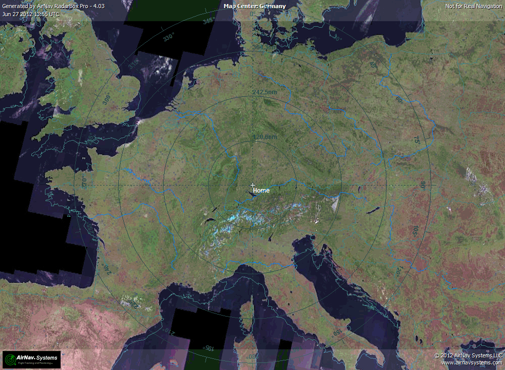
I think this problem already starts with downloading a satellite layer. Here is a screenshot:
You can see that the satellite layer is moved up a litle bit. The borders are not coincident.


I´m using Radarbox Pro 4.03.

Maximilian