anything
AirNav RadarBox
Welcome, Guest. Please login or register.
Did you miss your activation email?

Login with username, password and session length


Author Topic: AirNav ShipTrax  (Read 3156 times)

0 Members and 1 Guest are viewing this topic.

CAM

  • Full Member
  • ***
  • Posts: 111
    • http://www.planedaft.co.uk
Re: AirNav ShipTrax
« Reply #15 on: September 27, 2009, 02:21:14 PM »
Airnav,

No I dont have an AIS receiver, not sure how well it would work, I am 40+ miles from the coast.

pjm

  • RadarBox Beta Testers
  • Sr. Member
  • *
  • Posts: 477
Re: AirNav ShipTrax
« Reply #16 on: September 22, 2010, 06:34:49 AM »
I see on twitter that there are 5 "pre-deploy" shiptrax units being tested "all over" :)

http://twitter.com/AirNavSystems

Falcon

  • Jr. Member
  • **
  • Posts: 75
Re: AirNav ShipTrax
« Reply #17 on: October 05, 2010, 10:11:10 PM »
Hello,

You can put me on the list. No AIS receiver but I couldn't get much closer to the Pacific Ocean if that helps :-)

I'm not a programmer. I'm just really good at finding bugs :-)

Regards,
Darryl
« Last Edit: October 05, 2010, 10:17:24 PM by Falcon »

tarbat

  • ShipTrax Beta Testers
  • Hero Member
  • *
  • Posts: 4219
    • Radarbox at Easter Ross
Re: AirNav ShipTrax
« Reply #18 on: October 15, 2010, 08:15:24 AM »
Anyone else involved in beta testing, you can generate a TCP input for ShipTrax using my sp2trax utility (attached).  You don't need an AIS receiver.  Instead, this uses the Shipplotter network as a source of ships.  To use:

1. Startup Shipplotter, and make sure that the map covers your local area, and the sharing button is turned ON.

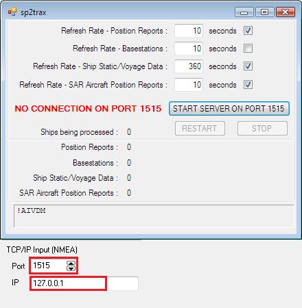
2. Startup sp2trax, and press the Start Server on Port 1515 button.

3. Configure ShipTrax beta to read port 1515.


It works by reading through the list of ships in ShipPlotter, and generates AIS messages at regular intervals for each of the ships.

Allocator

  • RadarBox24.com Beta Testers
  • Hero Member
  • *
  • Posts: 3568
Re: AirNav ShipTrax
« Reply #19 on: October 21, 2010, 02:51:08 PM »
Thanks tarbat - a nice utility.  I need to get started properly with the Beta testing and this will help a lot.

I've just spent a few days on holiday at Aberdovey on the west coast of Wales.  I took the laptop and my NASA AIS 'engine' receiver, but didn't pick anything up with either ShipTrax or ShipPlotter.  Looking at the ShipPlotter data now I'm back home, there isn't anything out there anyway!  I don't think that the NASA receiver is particularly sensitive - especially when used with my 70cm/2m amateur mobile antenna.  I was getting up to 10 miles range when I used it with ShipPlotter in the Liverpool area, but at Aberdovey I was just too far from the main shipping lanes.

The good news is that ShipTrax recognises the NASA receiver and was showing the 'startup' data line in the ShipTrax serial data test window  (it sends this when power is connected to the receiver).

Regards

Allocator

tarbat

  • ShipTrax Beta Testers
  • Hero Member
  • *
  • Posts: 4219
    • Radarbox at Easter Ross
Re: AirNav ShipTrax
« Reply #20 on: November 14, 2010, 04:15:17 PM »
Anyone know the format of the ML4 map files?

I'm trying to create an ML4 file to exactly match an OpenStreetMap image, but I need to convert the coords for the 4 corners of that map (TL, TR, BL, BR) into numbers that I can put into an ML4 file to exactly match the coordinates and zoom level.

My aim is to develop a utility to take the four coordinates, and convert them into an ML4 file.

Here's an example centred on my location:
0
2
99671?5647855886
464
38741
508401462
-20553101
0
12532839?4875021
-20272178
312215277

EI4GXB

  • RadarBox Beta Testers
  • New Member
  • *
  • Posts: 9
Re: AirNav ShipTrax
« Reply #21 on: December 21, 2010, 11:32:43 AM »
If not too late you can include me too.