anything
AirNav RadarBox
Welcome, Guest. Please login or register.
Did you miss your activation email?

Login with username, password and session length


Author Topic: COMMENTS: Announcing AirNav RadarBox 3D  (Read 37803 times)

0 Members and 1 Guest are viewing this topic.

tarbat

  • ShipTrax Beta Testers
  • Hero Member
  • *
  • Posts: 4219
    • Radarbox at Easter Ross
Re: COMMENTS: Announcing AirNav RadarBox 3D
« Reply #15 on: September 04, 2009, 02:48:14 PM »
If it's not a silly question, why don't professional ATC systems have 3D displays, or do they ?

Its a few years away yet, but its being prototyped.


Now if only Airnav could include the 3D weather display as well!!!

leomicen

  • New Member
  • *
  • Posts: 16
Re: COMMENTS: questions news configuratios ?
« Reply #16 on: September 04, 2009, 06:27:37 PM »
Friends, I am using the google translator because I do not speak English, know how to apologize.
The question is because Radarbox not have the option of conversion to metric meters instead of feet and miles instead of miles. Take into account that in Latin America and the USSR officially uses the metric system. Thank you very much

AirNav Support

  • AirNav Systems
  • Hero Member
  • *****
  • Posts: 4124
Re: COMMENTS: Announcing AirNav RadarBox 3D
« Reply #17 on: September 04, 2009, 06:33:11 PM »
leomicen,

Good point, we will take that into account for our next version.
Contact Customer/Technical support via:
http://www.airnavsystems.com/contact.html
[email protected]

pjm

  • RadarBox Beta Testers
  • Sr. Member
  • *
  • Posts: 477
Re: COMMENTS: Announcing AirNav RadarBox 3D
« Reply #18 on: September 04, 2009, 11:19:20 PM »
is because Radarbox not have the option of conversion to metric meters instead of feet and miles instead of miles. Take into account that in Latin America and the USSR officially uses the metric system.

I'd like to add my support to this suggestion. In Australia we also use the metric system. Knots, nautical miles & feet etc are all pretty meaningless to most consumers here.

Fenris

  • Guest
Re: COMMENTS: Announcing AirNav RadarBox 3D
« Reply #19 on: September 04, 2009, 11:46:05 PM »
is because Radarbox not have the option of conversion to metric meters instead of feet and miles instead of miles. Take into account that in Latin America and the USSR officially uses the metric system.

I'd like to add my support to this suggestion. In Australia we also use the metric system. Knots, nautical miles & feet etc are all pretty meaningless to most consumers here.

Options are good! I'm sure any Australian pilots will understand them, aircraft are still calibrated in these units.

AirNav Development

  • AirNav Systems
  • Hero Member
  • *****
  • Posts: 2545
    • AirNav Systems
Re: COMMENTS: Announcing AirNav RadarBox 3D
« Reply #20 on: September 05, 2009, 12:03:00 AM »
>Now if only Airnav could include the 3D weather display as well!!!

With RadarBox 3D a new world opens to the future of the system. As it is based in Google Earth kml layers could easily be added to the main view: this includes weather (real-time worldwide cloud cover layers), VORs, NDBs, 3D airspace, etc.

And we are already taking care of this. :-)

Anyway we see already a few more topics appearing in addition to the new flags and airline logos like: new layers, new 3D aircraft models, etc. The base will be there and users will be able to improve it.

FlightChaser

  • Guest
Re: COMMENTS: Announcing AirNav RadarBox 3D
« Reply #21 on: September 05, 2009, 01:47:03 AM »
It's great that Airnav continues to develop their software. I hope it doesn't delay an overdue 3.02 release! More bells and whistles are good, but get the original promise right first! Where's 3.02?

pjm

  • RadarBox Beta Testers
  • Sr. Member
  • *
  • Posts: 477
Re: COMMENTS: Announcing AirNav RadarBox 3D
« Reply #22 on: September 05, 2009, 02:32:21 AM »
Can we add better ACARS integration into this new version?

For example here we have an aircraft that RB is receiving ACARS data, but no ADS-B.

RadarBox know about he ACARS data, it has been told the Aircraft registration and Flight ID, but has not populated the Flight ID information (nor done an associated route lookup).


AirNav Development

  • AirNav Systems
  • Hero Member
  • *****
  • Posts: 2545
    • AirNav Systems
Re: COMMENTS: Announcing AirNav RadarBox 3D
« Reply #23 on: September 05, 2009, 02:40:38 AM »
FlightChaser: your question was explained on a previous post. The development team that is working on RadarBox 3D is not the same that is working on V3.03.

V3.03 has minor reported problems being corrected and we hope to release it to the beta testing group this Tuesday or earlier so we can release it to the public just after that (once we have the green light from the beta testers).

Terre

  • Jr. Member
  • **
  • Posts: 86
Re: COMMENTS: Announcing AirNav RadarBox 3D
« Reply #24 on: September 05, 2009, 07:51:42 AM »
Great idea to integrate GE into the application, Airnav. Hopefully access / an open interface will be available to use the various add-ons available to GE. Real-wheather display would be a snap this way.


Suggestions
As you were asking for suggestions - even though I am not a friend of permanent battology -, I would recommend to note the many, many, many ideas previously made in this thread: http://www.airnavsystems.com/forum/index.php?topic=2885.0
The popularity of each item can be found here: http://harvester.gofreeserve.com/poll.html

Excerpt :

# Module Suggestion
-----------------------------------------------------------------------------------
1 Alerts - Ability to click aircraft and jump to MyFLights entry & map
2 Alerts - Conditional Alerts (Excel style)
3 Alerts - Different actions for different alerts
4 Alerts - Different E-Mails for certain alerts
5 Alerts - Different sounds for different alerts
6 Alerts - Identification of alerts by Mode-S/Registration
7 Alerts - Keep a log of alerts
8 Alerts - Send SMS on alert
9 Alerts - Start record on alert
10 Desktop - Customizable toolbars – show selected icons only
11 Desktop - Moveable Toolbars
12 Desktop - Place interface at bottom
13 Desktop - Support dual display
14 Desktop - Undockable windows
15 Filter bar - International default data in drop down lists
16 Flight recorder - Faster playback of recordings - Option to speed up or scan recording file
17 Flight recorder - Record network traffic (at least for a certain region)
18 FTP  - Configurable FTP upload times
19 FTP  - Enhanced FTP information as number of flights tracked etc.
20 General - Different Lat/Lon format usage for display on map and entry in fields – have same format
21 General - Network traffic output
22 General - Option to allow the user to draw/edit Fixes, etc.
23 General - Port 30003 format
24 General - Remember all settings & screen setup
25 General - Squawk lookup
26 General - Update Database via Internet, registrations get updated automatically & download a picture
27 General - Use display style of contemporary software of air traffic control
28 Grid - Ability to add the symbols to the grid: 'Heard' 'ACARS' 'Visual'
29 Grid - Alternate lines in color (user defined color)
30 Grid - List of aircraft not „jumping“
31 Grid - User defined order of grid columns (MyFlights, etc.)
32 Grid / Map - Aircraft with curent alert colored
33 Interface - Show country of registration in flight details
34 Interface - Show counts flights received/ADS-B flights
35 Interface - Show/hide flight details
36 Interface Grid - Blank or numeric FlightID: use registration/stripped dahes, etc. to look up logo file
37 Map - 3 dimensional polar diagram
38 Map - Ability to draw temporary lines/dots on the map (as in PowerPoint presentation)
39 Map - Ability to measure distance with mouse (Google Earth style)
40 Map - Ability to select different options how flight tag is displayed (eg. Eurocat style)
41 Map - Ability to show/hide Outlines & Fixes by single/group selection
42 Map - Airways name
43 Map - Bearing and Distance to a target on map/to mouse position
44 Map - Display the route on the map for Non-ADS/B aircraft with Flight ID & valid route
45 Map - Draw trail line instead of dots for network flights
46 Map - Flash tags on Squawk ident
47 Map - Go to flight on Alert
48 Map - Highlight fix on map upon locate
49 Map - Longer trail lines (user definable time)
50 Map - Only show aircraft in a specific area
51 Map - Option to show/hide different fixes
52 Map - Pure full screen - no bars, no frame
53 Map - Real weather on map
54 Map - Rotate Map
55 Map - Select aircraft with mouse click and keep selected
56 Map - Shorter path vector (eg. One dot per 100 kts GS)
57 Map - Smaller increments when zooming in and out on map, or user selectable increments
58 Map - Smooth moving network traffic/path prediction (user sets this on/off)
59 Map - Tracks of aircraft to be displayed after aircraft time out
60 Map - Up/Down Arrows in tag
61 Map - User definable aircraft symbol (eg. Triangle, dot, cross, etc.)
62 Map - User definable aircraft tag (show only data selected)
63 Map - User definable Symbols for altitude change
64 Map & Interface - Highlight alerts in Grid/Map
65 Map & Interface - Show pop-up with details of selected aircraft on map/grid
66 MyLog - Ability to search using the keyboard
67 MyLog - Add sort function in MyLog
68 MyLog - Allow any date in MyLog (not just Today/Yesterday)
69 MyLog - Edit complete record / more than one cell at a time
70 MyLog - Print function for Mylog grid
71 MyLog - Search MyLog for FlightID
72 MyLog - Select fields of report
73 MyLog - Show real „Yesterday“ in MyLog (not Yesterday minus Today)
74 Preference - Adjust time for new flight to detect whether a new flight has started
75 Reports - Sort standard DAILY & YESTERDAY reports by Aircraft.Registration then Flights.EndTime
76 Smartview - Display METAR info in „MetarViewer“ style
77 Smartview - Include all alerts in Fleet Watch list - double-click aircraft in Fleet Watch to centre on
78 Smartview - Show/hide Weatherinfo in Smartview


Popularity

The TOPS of each category (in July):


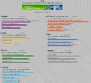
(click for larger view)

Vote for your most wanted RadarBox feature now!

> http://harvester.gofreeserve.com/poll.html

Using Firefox? Take this Link: http://harvester.gofreeserve.com/poll_fox.html

Allocator

  • RadarBox24.com Beta Testers
  • Hero Member
  • *
  • Posts: 3568
Re: COMMENTS: Announcing AirNav RadarBox 3D
« Reply #25 on: September 05, 2009, 03:35:47 PM »
Well that lot shouldn't take long to do :-0

wxwarn

  • Jr. Member
  • **
  • Posts: 58
Re: COMMENTS: Announcing AirNav RadarBox 3D
« Reply #26 on: September 06, 2009, 02:25:00 PM »
Is 3-D operationally the same using MyFLights view or does it always need to be on the Internet. It would be nice for 3-D to be used without Internet connection.

AirNav Support

  • AirNav Systems
  • Hero Member
  • *****
  • Posts: 4124
Re: COMMENTS: Announcing AirNav RadarBox 3D
« Reply #27 on: September 06, 2009, 02:26:52 PM »
Not sure what you mean, can you explain that again?
Contact Customer/Technical support via:
http://www.airnavsystems.com/contact.html
[email protected]

tarbat

  • ShipTrax Beta Testers
  • Hero Member
  • *
  • Posts: 4219
    • Radarbox at Easter Ross
Re: COMMENTS: Announcing AirNav RadarBox 3D
« Reply #28 on: September 06, 2009, 02:28:04 PM »
Will using the Google Earth 3D view in Radarbox 3D require internet connection?  I presume yes, since it has to access Google Earth for the 3D maps.

virtualradar

  • New Member
  • *
  • Posts: 13
Re: COMMENTS: Announcing AirNav RadarBox 3D
« Reply #29 on: September 06, 2009, 03:06:24 PM »
Hope it is free as a price increase will make it hard to sell as a dealer. All upgrade to the SBS-1 are free you cant start asking for price upgrades when you stated in the past that upgrades would be free.