AirNav RadarBox
Welcome, Guest. Please login or register.
Did you miss your activation email?

Login with username, password and session length


Author Topic: Experience your flights in 3D!  (Read 8467 times)

0 Members and 3 Guests are viewing this topic.

Andy Frost

  • Full Member
  • ***
  • Posts: 117
    • SquawkBox
Experience your flights in 3D!
« on: January 16, 2009, 02:07:53 PM »
SquawkBox now creates Google Earth files to give that 3D experience and providing a chance for you to share your airspace with others by sharing files.
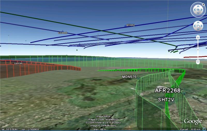


SquawkBox can create kml files for viewing in Google Earth so you can see your flights and the paths that they take. Flights are colour-coded just like RadarBox, green for descending, red for ascending and blue for level flight. The files generated can take three forms;

Static files containing flight paths collected over a period of time.
(http://www.gfrost.co.uk/SquawkBox/Manchester_flight_paths_05L_operation.kmz is an example file of the flight paths at Manchester airport, 05L operation, UK with en-route navigational aids added).

Files with animated flight paths for flights collected over a period of time.
(http://www.gfrost.co.uk/SquawkBox/Manchester_flights_example_movie.kmz is an example file of an animated flight paths file with 25 minutes worth of flights near Manchester airport, UK, 23R operation.http://www.gfrost.co.uk/SquawkBox/Manchester_flights_in_movie_plus_sigpoints.kmz is the static flight paths file corresponding to this animated file but with the UK's significant navigational points added along with other navigational aids).

A continously updated file showing the current positions of flights as output on Port 30003. (http://www.gfrost.co.uk/SquawkBox/Manchester_live_flights.kmz is an example file of what you can expect to see when viewing flights as they are output on port 30003. The data has been collected near Manchester airport, UK and set to show the full length of the detected flight paths. No navigational aids are added).
 

SquawkBox collects the data for these Google Earth files by saving all flights that it has positional data for as it runs. Data is stored up to a fixed storage maximum at which time older flights are deleted as new ones are saved. When the program has been running for a while (probably at least 10 minutes) you can get the program to output these saved flights to a Google Earth kml file via SquawkBox's system menu option Google Earth.

SquawkBox can also add the postions of navigational aids to the Google Earth terrain so you can see how aircraft steer towards various points (currently only VORs and NDBs are shown). In these days of satellite navigation it is questionable how much these contribute to the experience, but from my own experiences Manchester VOR seems to get plently of use with the VORs at Pole Hill and Trent being used for approach. If nothing else, it is perhaps interesting to see a VOR station pin-pointed in Google Earth.

The VORs/NDBs added are intended to be almost invisible when viewed from above, however if you tilt the viewpoint then you can see flight paths in relation to navaid positions. As far as navigational aids  go, only a handful of countries have so far been included with SquawkBox, but more can be fairly easily added, just make a request or send me a pm. Currently only significant points for the UK are available (unless I find data for other countries).

If you don't use SquawkBox because it doesn't support the squawk codes of your country but want to make use of this Google Earth feature then you can always run it minimized and access SquawkBox's GoogleEarth menu option by right-clicking on its icon when minimized.

The usual download site applies, http://www.gfrost.co.uk/SquawkBox/, note however that directories are now included in the archive so you will have to remember to extract with Use Folder Names to get the correct directory structure. It can be safely unzipped over the current version.

Have fun!

tarbat

  • ShipTrax Beta Testers
  • Hero Member
  • *
  • Posts: 4219
    • Radarbox at Easter Ross
Re: Experience your flights in 3D!
« Reply #1 on: January 16, 2009, 03:04:49 PM »
Andy, excellent work, will really compete with the Planeplotter Google Earth functionality.

I assume this can be shared over the internet in the same way that Planeplotter output to Google earth can?  For example, I'm currently running with ports open (not for long!!), so you should be able to view my live Radarbox data, just by opening the following link:

http://www.tarbat.gofreeserve.com/google_radarbox.kml
« Last Edit: January 17, 2009, 08:47:23 AM by tarbat »

Andy Frost

  • Full Member
  • ***
  • Posts: 117
    • SquawkBox
Re: Experience your flights in 3D!
« Reply #2 on: January 16, 2009, 03:08:28 PM »
hi tarbat, yes, your link works just fine. Looks like your coverage is a bit better than mine, despite your Scottish mountains!

lambertw

  • Full Member
  • ***
  • Posts: 204
Re: Experience your flights in 3D!
« Reply #3 on: January 16, 2009, 04:20:37 PM »
Absolute brill,,thank you Andy.

nortonbeak

  • Sr. Member
  • ****
  • Posts: 318
  • RadarBox MVT7100 PCR1000 M0NBK
Re: Experience your flights in 3D!
« Reply #4 on: January 16, 2009, 05:16:18 PM »
This is really good work, Andy. Thank you.

Allocator

  • RadarBox24.com Beta Testers
  • Hero Member
  • *
  • Posts: 3568
Re: Experience your flights in 3D!
« Reply #5 on: January 16, 2009, 05:21:06 PM »
Andy,

Amazing!  This is really excellent, I'll have a play over the weekend :-)

Allocater

rogerl

  • New Member
  • *
  • Posts: 14
Re: Experience your flights in 3D!
« Reply #6 on: January 16, 2009, 06:54:28 PM »
Excellent Andy. Thanks for that.

Andy Frost

  • Full Member
  • ***
  • Posts: 117
    • SquawkBox
Re: Experience your flights in 3D!
« Reply #7 on: January 16, 2009, 07:15:24 PM »
Thanks for your comments guys, appreciated. Looking at Tarbat's example link above I can see that it might be interesting to see flights levels as well as the flight number on the animated and live files, I'll look into making that an option. Perhaps aircraft registrations too if this information is of interest.

nortonbeak

  • Sr. Member
  • ****
  • Posts: 318
  • RadarBox MVT7100 PCR1000 M0NBK
Re: Experience your flights in 3D!
« Reply #8 on: January 16, 2009, 08:08:04 PM »
it might be interesting to see flights levels as well as the flight number on the animated and live files, I'll look into making that an option. Perhaps aircraft registrations too if this information is of interest.

The above would be of interest.

It seems that you have hit upon something really successful and could turn out to be keeping you very busy for the forseeable future.

Andy Frost

  • Full Member
  • ***
  • Posts: 117
    • SquawkBox
Re: Experience your flights in 3D!
« Reply #9 on: January 27, 2009, 11:23:49 AM »
I have updated the SquawkBox Google Earth facility as follows:

  • Flight Levels have been added to the live views and the 'movie' files.
  • Aircraft registrations have been added to the live views, the static flight path files and the 'movie' files.
  • Better colour change response to changes in flight status (i.e. level/climbing/descending).
  • Options added for configuration of the Google Earth data displayed; home location, colours, path labelling, transition altitude("FL to ft") and path width.
  • Should now work properly for people using ',' as their decimal separator (previous version might not have done).
  • NavAids added for Canada, Japan and US states; Virginia and Georgia.

Example Google Earth files available:

Usual download site, www.gfrost.co.uk/SquawkBox/. The program can be unzipped over existing versions.

I must credit Bones on the BaseStation site who did a stellar job testing this version and coming with suggestions.